Have you ever heard about how to create a tactical land navigation kit? Land navigation is critical to emergency wilderness survival. The U. S. Army has a vested interest in the vital skill of moving on the battlefield. Navigation over familiar and unfamiliar terrain in all types of weather conditions during daylight or evening hours makes our military a formidable force. An essential element of this task is training individual soldiers, Commissioned Officers, Warrant Officers, and Non-Commissioned Officers (NCOs) to be proficient at land navigation with a map, compass, and map protractor. Our sergeants prohibit the use of GPS devices during individual training on land navigation.
One of the techniques that I picked up in my military career was to have a personal land navigation kit in your rucksack as part of your packing list. It was during my time at Fort Benning, Georgia, that this technique first came to my awareness. Leaders are to be ready at all times to plot accurate map coordinates, mark accurate azimuths, and calculate and covert map and compass azimuths at all times. Of course, some did that better than others, as the old puns demonstrate regarding “butter bars” and land navigation. I still have my land navigation kit. It continues to have the original items that I used over the years. In this article, I will discuss how you can create your own Land Navigation Kit.
The Pouch
Spec-Ops Brand® Pack Rat Drop-In Organizer

The starting point for creating your land navigation kit is to purchase a tactical administrative pouch. The one that I use is the Spec-Ops Brand® Pack Rat Drop-In Organizer pouch. It has been around for a while and is now only offered in two colors: Black and Multicam®. The one that I used was initially in olive drab, and then I changed it out for the ACU digital camouflage version. This pouch is a little bulky for the average outdoorsman. However, it holds all of the items that I will identify for the packing list.
Description: 10” high, 7.25” wide x 3” thick. Total Capacity: 217.5 cubic inches.
The Packing List
1. Staedtler® Lumocolor® Permanent Markers, Super Fine Point
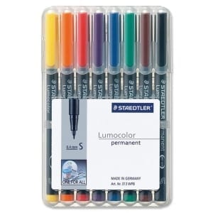
The Staedtler company makes the most excellent tools and equipment for draftsman, architects, and engineers. These markers are unique for using with laminated topographic maps. The recommendation for using permanent markers is that the ink will not run or bleed when it gets wet. Thus, this makes these markers and valuable tool for marking maps in rainy or wet conditions outdoors.
The super fine tip is excellent for making small marks and notes on a laminated map. For example, if you find a stream that is not on your map, the blue super fine tip marker can be used to mark it. You can also make small notes and labels near key terrain features as you navigate over your chosen route.
2. Staedtler® Lumocolor® Permanent Markers, Fine Point

These fine point markers from Staedtler are superb for making larger notes or markings on your map. These markers are great for marking roads or trails or other larger items on your map. The eight-count pack has all of the colors usually associated with maps. The fine-point and super fine-point markers are valuable writing instruments for your land navigation kit.
Note: Staedtler also makes an alcohol marker for removing lines and marks made with these pens. Thus, you can purchase this item if you are going to use permanent markers. Additionally, some people like to use hand sanitizer to remove lines, markings, or notes from their laminated maps.
3. Staedtler® Lumocolor® Permanent Marker 350 Wide Chisel Tip

The Staedtler broad-tip makers are great for marking tactical or operational boundary lines on a map. However, there is little application for tactical markings on a civilian map. So why the wide-tip markers? These markers are a great back up in case you need to make notes on objects like rocks if you become lost in the wilderness. The waterproof qualities of these markers allow them to be used as an alternative to the Sharpie® Industrial Permanent Markers.
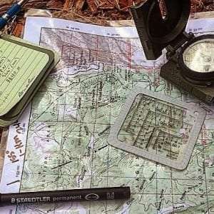
4. MGRS-UTM Map Protractor
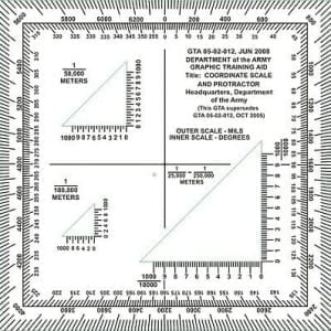
Map protractors are a must if you have a topographic map. My kit has typically at least three protractors. My kit has at least three protractors stored in the interior pocket of the pouch. You should always carry extra map protractors. If you are not sure about which ones to purchase, check out my previous article on map protractors.
5. ACCO® Banker’s Clasps

Banker’s clasps are used to hold your map to a map board. Some people still use map boards. These are exceptional items to help keep your map or other things in place. An alternative to these clasps is paper binder clips. Paper binder clips have other uses besides holding a map to a map board. However, I used the clasps during my military career, and they were great for my land navigation needs.
6. Westcott® Metal Ball Bearing Compass with Pencil

A pencil compass has limited applications outside of military map use. They are useful items for drawing arcs from a known point. The military use for a pencil compass is to identify distances and ranges from a known location, like your patrol base. However, there are a few instances where these would be helpful to land navigation for civilians. The most likely use would be to draw a communications arc for your handheld radio (HHR) from your bivouac site or bugout location on your map. Another use for the pencil compass is to help determine the range for line-of-site (LOS) considerations. Additionally, the golf pencil on the compass can be a backup writing utensil in an emergency.
7. Zebra® M-701 Stainless Steel Mechanical Pencil

A Zebra mechanical pencil has its best use on a non-laminated paper map. The permanent markers mentioned above will smudge or bleed through a paper map. The mechanical pencil is useful for drawing accurate azimuth lines and plotting grid points. It is also helpful for making marks or notes on the map as you use it.
8. Zebra® F-701 Ballpoint Stainless Steel Retractable Pen

The Zebra® pens are the best on the market for general use considerations. As with the mechanical pencil, the ballpoint pen is best for making notes and lines on a paper map. It also can be an emergency writing device should you need one. The other advantage of a ballpoint pen is that the ink is waterproof. A good alternative for the Zebra® is the Skilcraft U.S. Government pen.
9. Sharpie® Accent Pocket-Style Fluorescent Yellow Highlighters
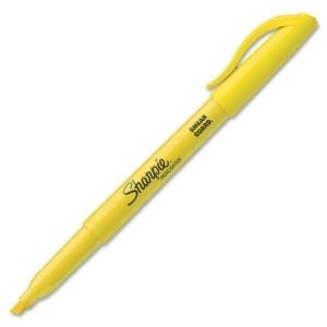
The next item in the land navigation kit is a yellow highlighter. The highlighter is a versatile item. It not only highlights important or critical information on your map, but it also glows in the dark when a blue-filtered light shines on the marked item (Tscherne, “A Map Marker Lighter,” Ranger Digest No. VII, Paradise, CA: Loose Cannon, 2017, 117). Incidentally, this technique does work. I tried it by highlighting something on a note card that I had laying around my office and using the blue filter on my L-light flashlight.
Final Comments
A land navigation kit is a great item to consider adding to your loadout. The kit discussed in this article is a little bulky for most outdoorsman. However, I would recommend that you use this article to come up with your own user-friendly land navigation kit. The items in this kit have been used in a multitude of environments and scenarios. They work for their intended purposes and help make the task of map reading and land navigation more efficient. Therefore, enjoy experimenting with your own personalized land navigation kit.
This post may contain affiliate links which means I may receive a commission from purchases made through the links. I only recommend products I personally use and love, so if you support what we are doing, thanks for clicking.